

Trip overview
Gokyo, Chola-pass Trek 19-day
The Gokyo-Chola-pass trek is a challenging but rewarding adventure across some of Nepal’s most stunning terrain. Trekking via the Khumbu Glacier, the Himalayas’ largest glacier, is just one of the highlights of this trek and adventure. This trek is a once-in-a-lifetime opportunity to witness the incredible strength and beauty of nature. The hike also passes by the beautiful Ngozumpa Glacier, the largest glacier in Nepal’s Himalayas. This trek, you will view some of the most breathtaking scenery in the world and get the opportunity to traverse one of the Himalayas’ most challenging crossings, but the effort is well worth it. The best months to visit Gokyo Chola Pass via EBC Trekking are September through November and March through May.
Gokyo – Chola Pass Trek Highlights
The Gokyo-Chola Pass Trek is one of the most adventurous and scenic trekking routes in the Everest region. It offers breathtaking landscapes, pristine glacial lakes, and a thrilling high-altitude pass crossing. Here are the key highlights:
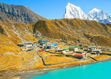
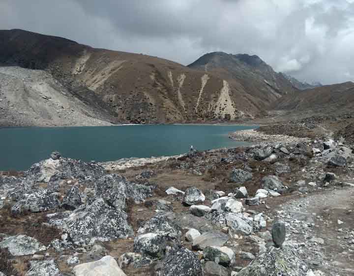
Stunning Gokyo Valley & Lakes: Explore the beautiful Gokyo Lakes, the world’s highest freshwater lake system.Visit Gokyo Ri (5,357 m) for a panoramic view of Everest, Lhotse, Makalu, and Cho Oyu.
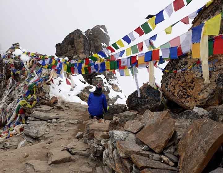
Thrilling Cho La Pass (5,420 m): Cross the challenging Cho La Pass, a high-altitude pass covered in ice and snow. Experience a rugged, adventurous route between Gokyo and Everest Base Camp.
Everest Base Camp & Kala Patthar: Reach the iconic Everest Base Camp (5,364 m), the closest you can get to Mount Everest. Climb Kala Patthar (5,545 m) for a breathtaking sunrise view of Everest and surrounding peaks. Diverse Landscapes & Sherpa Culture: Trek through picturesque villages like Namche Bazaar, Dole, Machhermo, and Dzongla. Experience the unique hospitality and culture of the Sherpas. Visit Tengboche Monastery, the most famous Buddhist monastery in the region. Ngozumpa Glacier & Dramatic Terrain: Cross the Ngozumpa Glacier, the longest glacier in the Himalayas. Witness dramatic landscapes, including icy mountains, rocky ridges, and alpine meadows.
Flora and Fauna of Gokyo – Cho La Pass Trek
Subtropical & Temperate Forests (2,500 m – 3,500 m): Rhododendron (national flower of Nepal, blooms in spring, turning forests red and pink) Pine, Oak, and Birch Trees Juniper and Hemlock Mosses and Ferns in shaded, moist areas
2. Alpine Region (3,500 m – 4,500 m)
Dwarf Rhododendrons (smaller shrubs adapted to cold), Blue Himalayan Poppies, Edelweiss (a rare white flower found in high-altitude regions) Juniper bushes (used by Sherpas in religious ceremonies)
3. Tundra & Glacier Zone (Above 4,500 m)
Sparse Vegetation: Only hardy grasses, lichens, and mosses survive. Glacial moraines: Mostly barren with occasional alpine flowers, Yak Pastures: Some high-altitude grasslands where yaks graze
The Gokyo-Cho La Pass Trek passes through the Sagarmatha National Park, a UNESCO World Heritage Site, which is home to diverse ecosystems. From lush forests at lower altitudes to alpine tundra and icy landscapes at higher elevations, this trek offers a rich variety of flora and fauna.
1. Mammals
Himalayan Tahr (a wild mountain goat found on rocky cliffs). Musk Deer (shy and mostly seen at dawn/dusk). Snow Leopard (rare and elusive, but lives in the high-altitude regions). Red Panda (lives in lower forests but rarely seen). Himalayan Marmot (large, furry rodents found near Gokyo Lakes). Blue Sheep (Bharal) (prey for snow leopards, seen on grassy slopes). Yaks (domesticated animals used for carrying loads and providing milk)
2. Birds
Himalayan Monal (Danphe): (Nepal’s national bird, brightly colored) Snow Pigeon (common in rocky areas). Golden Eagle (soars high in search of prey). Himalayan Griffon Vulture (feeds on carcasses). Blood Pheasant (often seen in rhododendron forests)
3. Other Wildlife
Himalayan Wolf (extremely rare). Pika (small mountain rodent, looks like a rabbit). Tibetan Snowcock (commonly seen in high-altitude areas) The Gokyo-Cho La Pass-Everest Base Camp (EBC) trek is one of the most scenic and adventurous trekking routes in the Everest region. It takes you through diverse landscapes, varying vegetation zones, and a range of atmospheric conditions. Here’s an overview:
Sagarmatha National Park
Sagarmatha National Park, located in the Solukhumbu District of Nepal, is one of the most spectacular protected areas in the Himalayas. Covering an area of 1,148 square kilometers, it is home to Mount Everest (Sagarmatha in Nepali), the world’s highest peak at 8,848.86 meters. Established in 1976 and designated a UNESCO World Heritage Site in 1979, this national park is a globally recognized region of natural beauty, biodiversity, and cultural significance.
Geography and Landscape
The park lies at an altitude range of 2,845 meters (Monjo) to 8,848.86 meters (Everest summit). It is characterized by rugged terrain, deep valleys, glaciers, and towering Himalayan peaks, including Lhotse (8,516 m), Nuptse (7,861 m), Ama Dablam (6,812 m), and Thamserku (6,623 m). The Dudh Koshi River and its tributaries flow through the park, originating from glacial melt.
Sagarmatha National park : Flora and Fauna
Sagarmatha National Park, a UNESCO World Heritage Site, is located in the Everest region of Nepal and is home to diverse flora and fauna, adapted to its high-altitude environment.
Flora:
Lower altitudes (below 4,000m): Rhododendron, birch, juniper, and fir forests.Higher altitudes (above 4,000m): Alpine scrub, grasslands, and barren rocky terrain with minimal vegetation.
Fauna:
Mammals: Snow leopard, Himalayan tahr, red panda, musk deer, Himalayan black bear, and Tibetan wolf. Birds: Himalayan monal (Nepal’s national bird), snow partridge, blood pheasant, and various species of eagles and vultures.
Sherpa Culture and Heritage
The park is home to the Sherpa people, renowned for their mountaineering skills. Famous Buddhist monasteries like Tengboche Monastery, the spiritual center of the Everest region. Festivals such as Mani Rimdu are celebrated annually with colorful ceremonies and mask dances.
Vegetation & Landscape
Sagarmatha National Park: Landscape and Vegetation
Some of Nepal’s most stunning scenery and a variety of vegetation zones may be found at Sagarmatha National Park, a UNESCO World Heritage Site. Mount Everest (Sagarmatha, 8,848.86m), the highest peak in the world, and many other tall mountains, deep valleys, glaciers, and alpine ecosystems are all part of this region, which is in the Khumbu.
Lower Region (Lukla to Namche, 2,800 m to 3,500 m)
Vegetation: dense rhododendron, pine, juniper, and fir forests. Oak trees are also common. Atmosphere: cool in the mornings and evenings, pleasant during the day. Oxygen levels are still comfortable.
Mid-Region (Namche to Gokyo & Dingboche, 3,500m to 4,800m)
Vegetation: gradual thinning of forests, replaced by alpine shrubs, dwarf rhododendrons, and juniper bushes. Atmosphere: Crisp, dry air with increasing cold, especially in the mornings and nights. The winds are stronger.
High Region (Gokyo, Cho La Pass & EBC, 4,800 m to 5,545 m)
Vegetation: Almost barren with moss, lichens, and some alpine grasses. Glacial mountains dominate the landscape. Atmosphere: harsh, dry, and cold. Strong winds, sub-zero temperatures at night, and lower oxygen levels.
Spring (March to May)—Best Season
Temperature: Daytime: 10°C to 20°C | Nighttime: -5°C to -10°C Vegetation: rhododendrons in bloom, lush greenery in lower areas. Atmosphere: stable weather, clear skies, and moderate temperatures.
Summer/Monsoon (June to August): Challenging
Temperature: Daytime: 15°C to 25°C | Nighttime: 0°C to -5°C Vegetation: Lush greenery in lower regions, but trails are muddy. Atmosphere: high humidity, cloudy skies, and frequent rainfall, increasing the risk of landslides in lower areas.
Autumn (September to November)—Best Season
Temperature: Daytime: 10°C to 18°C | Nighttime: -5°C to -15°C Vegetation: dry, golden brown shades with clear views. Atmosphere: Crisp, fresh air with excellent visibility. Stable conditions make it one of the best times to trek.Winter (December to February): Extreme Cold Temperature: Daytime: 5°C to 10°C | Nighttime: -15°C to -25° Vegetation: snow-covered trails, frozen lakes, and bare landscapes. Atmosphere: harsh, windy, and freezing conditions. High passes like Cho La are often closed due to heavy snowfall.
Food and Accommodation on the Gokyo Chola Pass Trek
Accommodation: Accommodation along the trek consists of teahouses (lodges) run by local Sherpa families. These are basic but comfortable, offering:
Rooms: Simple twin-sharing rooms with beds, blankets, and pillows. In higher altitudes, it’s advisable to bring a sleeping bag for extra warmth.
Bathrooms: Lower elevations have attached bathrooms, while higher regions mainly have shared toilets. Hot showers are available for an extra charge. Electricity & Charging: Available in most lodges, but charging electronic devices costs extra. Some lodges use solar power. Wi-Fi: Available at major points like Namche Bazaar, Gokyo, and Gorak Shep but often slow and expensive.
Food Options
Teahouses provide a variety of meals, mainly Nepali and Tibetan dishes, along with some Western options. The most common choices include:
Breakfast:
Tibetan bread or chapati with honey/jam, Pancakes (plain, apple, chocolate),Porridge (oatmeal, muesli), Eggs (boiled, fried, scrambled, omelet),Tea, coffee, hot chocolate
Lunch & Dinner: Dal Bhat (rice, lentil soup, vegetables, pickles) – Unlimited refills and best for energy, Sherpa stew – A thick soup with vegetables, potatoes, and sometimes meat, Fried noodles or rice with vegetables or eggs, Momos (dumplings) – Either steamed or fried.Pasta, macaroni, or spaghetti with tomato sauce or cheese, Pizza (available in Namche, Gokyo, and a few other places),Yak steak (available in some lodges, but not common)
Snacks & Drinks:
Tea (black, milk, ginger, lemon, mint, green),Coffee (instant or brewed in Namche and Gokyo),Hot chocolate, Energy bars, chocolates, and biscuits (can be bought in lodges but expensive). Popcorn (sometimes available in higher lodges)
Special Considerations for Food & Accommodation
Vegetarian Meals: Recommended at higher altitudes to avoid food poisoning from poorly preserved meat. Water: Bottled water is expensive at higher altitudes. Carry a reusable bottle and use purification tablets or a SteriPen. Food Prices: Prices increase as you go higher due to transportation costs (porters/yaks carry supplies).
Crowds & Booking: In peak trekking seasons (spring & autumn), teahouses may be full. Booking in advance (especially in Gokyo and Lobuche) is a good idea.
Best Season to Trek
Spring (March-May): Best for blooming flowers and moderate weather. Autumn (September-November): Best for clear skies, great visibility, and stable conditions. For Cho La Pass, it’s highly recommended to avoid winter due to snow accumulation and summer due to slippery conditions.
Physical Fitness Level Required for Gokyo Chola Pass Trek
The Gokyo Chola Pass Trek is a challenging and strenuous trek that requires a high level of physical fitness, endurance, and mental resilience. It combines long trekking days, steep ascents and descents, high altitude, and the technical crossing of Cho La Pass (5,420m).
Fitness Requirements
Cardiovascular Endurance: You will be trekking 5-8 hours daily at high altitude with reduced oxygen levels. Good cardio fitness helps in efficient oxygen utilization and prevents altitude sickness. Recommended Training: Running, cycling, swimming, stair climbing, or hiking with a backpack (3-4 times a week for at least 3 months before the trek). Strength & Stamina, Leg strength is crucial for steep ascents and descents. Carrying a backpack (if without a porter) requires good core and upper body strength. Recommended Training: Squats, lunges, leg presses, deadlifts, and core exercises like planks and crunches.
Altitude Adaptation: The trek reaches a maximum altitude of 5,545m (Kalapatthar) and 5,420m (Cho La Pass), where oxygen levels are significantly lower. Acclimatization days (at Namche and Gokyo) are necessary to prevent Acute Mountain Sickness (AMS). Recommended Training: If possible, trek at high altitudes before the trip, or use an altitude training mask to simulate conditions.
Technical Skills (for Cho La Pass)
The Cho La Pass crossing includes steep icy sections and rocky terrain. Trekking poles and crampons (when icy) help with stability. No mountaineering experience is required, but confidence in walking on rough and icy trails is helpful.
Mental Preparation: Expect harsh weather, long trekking hours, and basic facilities.Mental resilience helps in overcoming challenges and maintaining motivation.
Who Can Do This Trek?
Ideal for: Experienced trekkers who have completed moderate to difficult treks (e.g., Annapurna Base Camp, Langtang Valley, or Everest Base Camp). Physically active individuals who engage in regular endurance training (hiking, running, gym workouts). Those with good mental determination to handle challenging conditions.
Final Preparation Tips
Train at least 3-4 months before the trek. Do altitude hikes (if possible) to test endurance. Pack properly, including trekking poles, crampons required), and proper layering. Acclimatize well and follow a slow and steady pace.
Popular Places
Gokyo and Cho La Pass are among the most popular trekking destinations in the Everest region of Nepal. This route is famous for its breathtaking landscapes, high-altitude adventure, and incredible views of the Himalayas, including Everest, Lhotse, Makalu, and Cho Oyu.
Key Highlights of Gokyo & Cho La Pass Trek:
Gokyo Valley & Gokyo Lakes: A stunning valley featuring the turquoise blue Gokyo Lakes, the highest freshwater lake system in the world.
The view from Gokyo Ri (5,357m) offers one of the best panoramic views of Everest and its surrounding peaks.
Cho La Pass (5,420m) A challenging and adventurous high mountain pass that connects Gokyo Valley with the Everest Base Camp trail.: The pass involves glacier crossings and steep ascents, making it a thrilling experience for trekkers.
Everest Base Camp & Kala Patthar: After crossing Cho La Pass, trekkers join the Everest Base Camp (5,364m) route, one of the most iconic trekking destinations.
Kala Patthar (5,545m) provides the most spectacular close-up views of Mount Everest.
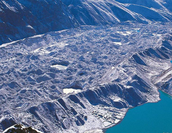
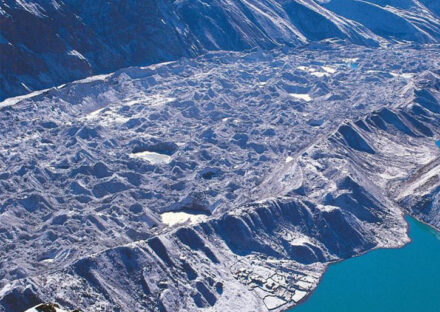
Ngozumpa Glacier: The longest glacier in Nepal, stretching from Cho Oyu down to the Gokyo Valley.The glacier crossing is a unique experience on this trek.
Sherpa Culture & Villages: Visit traditional Sherpa villages like Namche Bazaar, Dole, Machhermo, Gokyo, and Lobuche. Explore Tengboche Monastery, the spiritual hub of the region.
Conclusion: Gokyo Chola Pass Trekking
The Gokyo Chola Pass Trek is an exhilarating journey that combines breathtaking landscapes, high-altitude adventure, and rich Sherpa culture. This trek is ideal for those seeking both a challenging and rewarding experience in the Everest region of Nepal. With its stunning turquoise lakes, the dramatic Cho La Pass (5,420m), and the iconic views of Everest from Gokyo Ri and Kalapatthar, this trek is truly a bucket-list adventure.
From the tranquil beauty of Gokyo Valley to the thrilling crossing of Cho La Pass, and finally reaching the legendary Everest Base Camp, every step offers an unforgettable experience. This trek not only tests endurance but also rewards trekkers with some of the most spectacular Himalayan panoramas.
Whether you are an experienced trekker or an adventurer looking to challenge yourself, the Gokyo Chola Pass Trek is a journey of a lifetime, blending nature, adventure, and cultural immersion in the heart of the Himalayas.
Gokyo Chola Pass Trekking Note
The Gokyo Chola Pass Trek is one of the most adventurous and scenic treks in the Everest region, combining the stunning Gokyo Lakes, the challenging Cho La Pass (5,420m), and the classic Everest Base Camp trail. This trek offers breathtaking views of Mt. Everest (8,848m), Lhotse, Makalu, Cho Oyu, and other Himalayan giants.
Key Highlights
Explore the pristine Gokyo Lakes (4,750m), the world’s highest freshwater lake system. Climb Gokyo Ri (5,357m) for a panoramic view of Everest, Lhotse, Makalu, and Cho Oyu. Cross the Cho La Pass (5,420m), a challenging but rewarding high-altitude pass. Visit Everest Base Camp (5,364m) and hike up to Kala Patthar (5,545m) for the best close-up view of Everest. Experience the unique Sherpa culture, monasteries, and traditional villages. Walk through diverse landscapes, from lush forests to glaciers and moraines.
Other trekking routes in the Everest region:
Similarly, Himalayan Realms Treks offers a wide range of trekking routes in the Everest region, including both classic trails and off-the-beaten-path adventures. Moreover, these routes cater to trekkers of all skill levels, from beginners seeking a short and scenic trek to experienced hikers looking for a challenging expedition. In addition, the breathtaking landscapes, diverse cultural experiences, and well-established trekking infrastructure make the Annapurna region an ideal destination for adventurers. Below are some of them for your information.
6, Gokyo lake with Renjo-la pass trek
Short Itinerary
Day 01: Arrival in Kathmandu
Day 02: Full-Day Kathmandu
Day 03: Fly to Lukla Trek to Phakding
Day 04: Trek to Namche Bazaar
Day 5: Rest day for Acclimatization
Day 06: Trek to Dole (4,200 m) – 6 hrs
Day 07: Trek to Machhermo
Day 08: Hike to Gokyo Ri
Day 09: Rest Day for Acclimatization (4,700 m)
Day 11: Trek to Cross Cho La Pass , Dzongla
Day 12: Trek to Lobuche
Day 13: Trek to Gorakshep-Everest Base Camp
Day 14: Trek to Pheriche (4,240 m) – 7-8 hrs
Day 15: Trek to Namche Bazaar
Day 16: Trek to Lukla
Day 17: Fly to Kathmandu
Day 18: Buffer Day
Day 19 Final Departure
Itinerary
Welcome to Kathmandu Tribhuwan International Airport
When you arrive at Kathmandu Tribhuvan International Airport, our representative will pick you up, and today you hear the Nepali word for hello "namaste". A word that you will probably never forget after this trip. He will then take you to your reserved hotel. After check-in at the hotel, you will be briefed about your trekking tour program. After the briefing session, you can relax and unwind at the hotel. If you want to get familiar with this place, you can go for a walk in the Thamel area in the evening.
Meals included: None
After having breakfast we embark on a journey with an experienced tour guide to the historical and spiritual attractions of Kathmandu, which is also a UNESCO World Heritage Site. You will visit the historic Kathmandu Durbar Square, the sacred Hindu Temple of Pashupatinath, the famous Monkey Temple (Swayambhunath) and the Buddhist Temple (Boudhanath), one of the largest stupas in the world.
Meals included: Breakfast
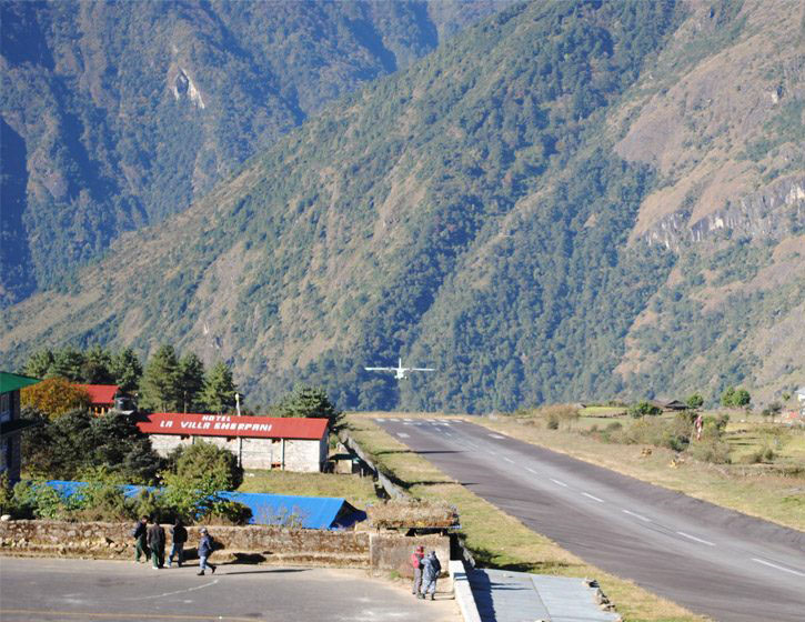
After 30-35 minutes flight you will land at Lukla Airport (Tenzing Hillary Airport) from Kathmandu. During the flight you can see some of the highest mountains in the world including Cho Oyu (8,153m), Lhotse (8,516m), Gauri Shankar (7,145m), Menlangtse (7,181m) and sometimes Mount Everest. After an exciting landing and a warm welcome at Lukla airport, you will be met by your porters and other members of our team who will carry your excess luggage every day until you return to Lukla. We also prepare your goods for shippers. As soon as everything is ready the 3 peaks trek begins and we move towards the daily goal of reaching our first overnight stay. Leaving Lukla behind, after three hours mainly uphill and flat we finally reach the beautiful village of Phakding situated on the Doodh Kosi river. Her we can take a short walk in Phakding village or even go for a walk in the nearby Gompa. Night stay at a lodge in Phakding. Meals included: Breakfast, lunch, and dinner
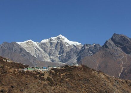
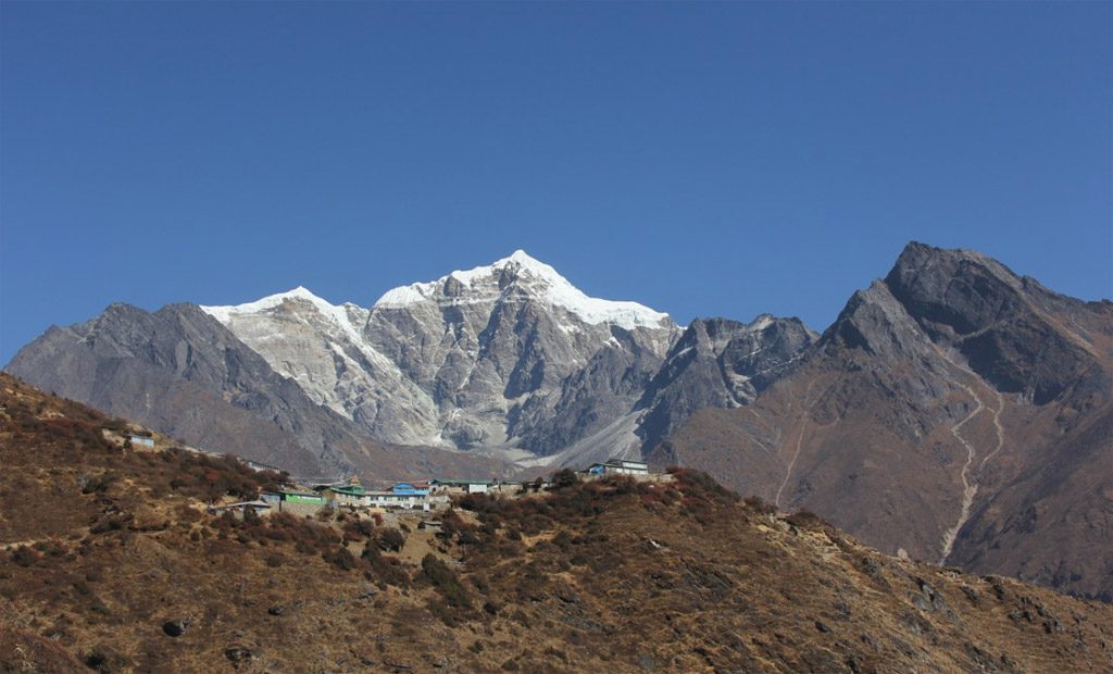
Today is the second day of your trek, and our destination is the Namche Bazaar. Without wasting time, we leave Phakding and walk towards Monju over some suspension bridges and small settlements. Monju is popularly recognized as the gateway to Sagarmatha National Park. Upon arrival at the entrance at Sagarmatha National Park the team leaders will take care of the necessary documents for entry into the park. We then enter the national park, after a short vertical descent taking us over some suspension bridges the path then climbs taking you over the stunning "Hillary Suspension bridge" you then continue on a steep climb into Namche Bazaar, where you see the first view of Mount Everest along with other peaks. You will spend a night at a Lodge in Namche Bazaar.
Meals included: Breakfast, lunch and dinner
Namche Bazar rest day for acclimatization:- Acclimatization day at the Namche Bazaar
When you reach Namche, you cross the 3000m mark which puts you at risk of altitude sickness. It takes some time for our body to adapt to this rapidly changing altitude and falling temperature. So stay at Namche Bazaar for a day and reduce the risk of altitude sickness. On this day, you can take a short walk to the Everest View Hotel to watch the sunrise over Everest. You can also enjoy the sunrise and sunset in the panorama of the Himalayas from Sagarmatha National Park Headquarters. You can also stop by at Namche Bazaar and explore the Sherpa lifestyle and culture. Meals included: Breakfast, lunch and dinner
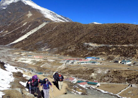
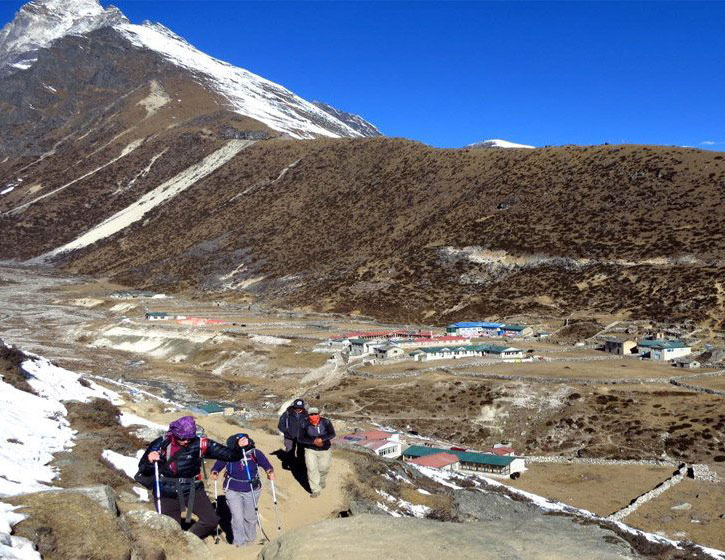
Trek from Namche Bazaar to Dole (4040m.): – Trek via Khumjung, it takes about six hours. From Namche the route heads up all the way to Khumjung, a picturesque village which also has its own gompa at the top end of town. Here, you can have excellent views of Thamserku, Kantega and Ama Dablam. Soon after leaving Khumjung the trail climbs to a large chorten on top of a ridge. This ridge descends from Khumbila, a 5734m peak, said to be the abode of the patron God of the Khumbu region. The trail descends slightly towards the Sanasa and then trail ascends up to Mongla (4000m.). From here, you can see panoramic views of various mountains. You trek steeply descending the pass through Phortse Tenga and from there, the trail climbs steeply to Dole, through rhododendron and birch forest festooned with hanging mosses and lichens. You can enjoy a delicious meal at Phortse Tenga (3650m.). Stay overnight at lodge or camp. Meals included: Breakfast, lunch and dinner
Dole to MaCharmo (4150m): – Trek from Dole to Machhermo which takes about five hours. From Dole you climb steadily along the side of the valley, where small and thorny bushes give way to scrub juniper as the altitude increases. The trail passes many summer settlements, which are used when yaks are taken to these pastures to graze in the summer months. Ahead of you are excellent views of Cho Oyu, while back down the valley are the peaks of Kantega and Thamserku. This is a short day and you will arrive at Machhermo in time for lunch. Stay overnight at lodge or camp.Meals included: Breakfast, lunch and dinner
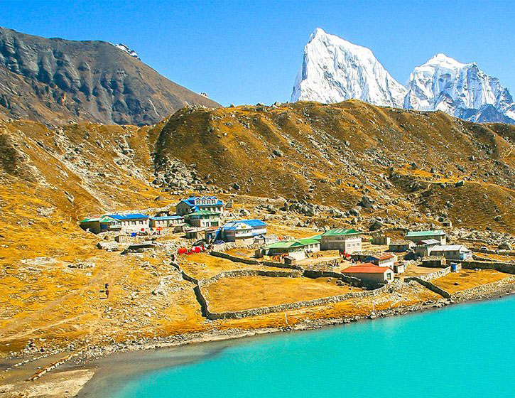
Macharmo to Gokyo (4750m) :-Trek from Machhermo to Gokyo which takes about four and half hours. Today you head for the lakes at Gokyo. You follow a very scenic path to Pangka and then descend slightly, following one of the melted-water Rivers which flow down the west side of the Ngozumpa Glacier. You climb a steep rocky incline into the valley by the side of the glacier, passing the first of the holy lakes. You soon arrive at the second of the lakes, crossing the path which heads across the glacier to Cho La (5420m.), your route to Lobuche and Everest and later in the trek. The third lake is known as Dudh Pokhari and on its eastern shore is the settlement of Gokyo. Walking by the side of the lake, the scenery is magnificent with the summits of Cho Oyu and Gyachung Kang reflected in its emerald green waters. Stay overnight at lodge or camp. Meals included: Breakfast, lunch and dinner
Rest day at Gokyo and we do some excursion in and around Gokyo valley. Gokyo is a trade centre where the Sherpa people run lodges to provide the best services to trekkers. Gokyo is situated by the side of Ngozumpa glacier, the biggest glacier of Nepal. This day you can make a side trip to the Fifth Lake via the Fourth Lake. Stay overnight at lodge or camp. Meals included: Breakfast, lunch and dinner
Today, we continue our journey to Thangnak (Dragnag). At a point beyond the southern end of Lake Taboche Tsho, where a cairn marks a fork in the trail, we branch left, making any easy rise across the hill, and summit the moraine wall at a saddle. From here, we will get a spectacular view northward up the length of the Ngozumpa Glacier to Cho Oyu, as well as Cholatse and Taboche in the southeast. The trail now drops onto the glacier, winding around ice cliffs, rocky humps, skirting small lakes, and crossing glacial sand flats. There are stunning vistas in all directions. After crossing the glaciers, the trail falls into the ablation valley below our overnight Stop in Thangnak, which has three extremely poor lodges and a couple of shelters. Trekking time: 3-4 hours. Meals included: Breakfast, lunch and dinner
Today's trail climbs slowly to a cairn on the top of a moraine ridge, then falls into a valley to arrive at a rough region of rocks and boulders known as Cho La Base Camp and Phedi (4,930m/16,175ft), which means "at the foot of the hill". We'll now stick close to the right-hand rock wall, where cairns mark the way down. The sights ahead will be stunning. The steep drop now continues down rocky "steps" until we reach an easy trail that leads to the valley's bed. The remainder of the hike to our overnight stay in Dzonglha takes us through this gorgeous valley, where we will be able to take in the breathtaking vistas. Dzonglha contains a A few basic lodges and camping areas in a walled courtyard. Dzonglha provides an excellent close-up picture of Cholatse's north-east face (6,335m/20,785ft), with Chola Tsho lake (4,590m/15,059ft) to the south. We stay the night in Dzonglha. Trekking time: 6-7 hours.
Trekking to Everest Base Camp is certainly a challenge. With more than half of our tour behind us, we enjoyed the simplicity of day 9. Our journey from Dzongla to Lobuche provided us with additional breathtaking vistas without having to traverse glaciers. This was the day we left the more secluded routes of the Everest Base Camp route. We traveled along the undulating trails from Dzongla to Lobuche on the valley's left side. On our right, we were accompanied by the Khumbu Glacier, which was covered in debris with shards of ice poking through. After a couple hours of easy trekking, we made it to Lobuche. During the night in Lobuche.
Meals included: Breakfast, lunch, and dinner
Trek to Everest base camp and return to Gorakshep walking 7 to 9 hours
You are now very close to Everest Base Camp, but it is a challenging day. You first arrive at Gorak Shep and check into a hotel after going down a gentle slope. It has been a walk of almost 3 hours, and it seems to be a little more due to the height that you will have reached today. You have to walk slowly and steadily, and with the help of your guide, you'll be there in no time. The view is excellent today as towering snow-capped peaks surround you. After a light lunch we drive to Everest Base Camp which takes 5-6 hours to drive back to Gorakshep where we will sleep tonight. You will see prayer flags when you reach Everest Base Camp, and the vast mountains you will see in front of you are not Everest but Lhotse and Khumbutse. Behind these mountains, you can only catch a glimpse of Everest. Then return to Gorak Shep to sleep and have dinner there. Meals included: Breakfast, lunch, and dinner
Everest Base Camp is the main camp for the Mountaineers situated at the elevation of 5,364 meters. The Trekkers feel very happy to reach there as it makes them a lifetime memory for their adventurous fulfillment.
descending till Pangboche and cross the Dudkoshi river and lunch in the Devuche after lunch ascending about 45 minutes till to the Tengboche after down to phungithanga about 1:45 and cross the again Dudkoshi river and start to climbing 1 hrs reach to the Kyanjungma after Kyanjumna to Namche is gradually flat about 2 hrs. Stay overnight at the Lodge in Namche.
After breakfast start to descending about 1 hrs to a dhud Koshi river and cross the suspense bridge. Dudhkoshi River to Jorselle is about 1 hrs follow the riverside of Dudh Koshi and reach Jorselle before Jonelle also we need to cross again the suspensive Dhud Dhudh Koshi bridge and reach to Jonelle there has tea, coffee and continue to the Namche Bazaar. After tea, coffee accents a few minutes and cross the bridge of Dhudkoshi and start to up till national park office at Monju village than all the up and down about 2:30 reach to Phakding. Stay overnight phakding in the teahouse.
From Lukla to Kathmandu by flight approximately 30 minutes about the flight. From Kathmandu, domestic airport transfer to the hotel and day time is rest and visit Thamel area for a souvenir to your family.
From Lukla to Kathmandu by flight approximately 30 minutes about the flight. From Kathmandu, domestic airport transfer to the hotel and day time is rest and visit Thamel area for a souvenir to your family.
today is free or last minute you have few hrs. special shopping for your relatives. If you have more time you can do some shopping or sightseeing then we will drop you to the International airport to catch your flight back to your home and wish for your Safe journey.
Included
- All airport and hotel transfers
- 2-night hotel in Kathmandu with B/B plan.
- National Park permit & Pasang Lhambu village entry permit.
- Flight fare from Kathmandu-Lukla-Kathmandu.
- Accommodation in the tea house, During the trek.
- Food:- Breakfast, Lunch, Dinner and Tea/coffee during trek.
- Guide: – including salary, insurance, equipment, flight, food and lodging.
- Porter: – including salary, insurance, equipment, food and lodging.
- For guest: -Down jacket, Good sleeping bag (down jacket and sleeping bag are to be returned after trip completion).
- Transfer from airport to hotel in Kathmandu
- All government and local taxes.
- Final departure from hotel to international airport transfer.
Not Included
- Food in Kathmandu ( Lunch & Dinner).
- Bakery food during the trek.
- Nepal Visa fee.
- International airfare.
- Extra night accommodation in Kathmandu
- Travel and rescue insurance if guest get mountain sickness and need to rescue helicopter.
- Personal expenses example (phone calls, laundry service , bar bills, battery recharge, WIFI charge, extra porters, bottle water or boiled water, shower etc.)
- Tips for guide and porters
Useful Info
1. Trek Overview
Duration: 15–18 days
Max Elevation: 5,545 m (Kala Patthar)
Difficulty: Challenging
Best Seasons: Spring (March–May) & Autumn (Sept–Nov)
Starting Point: Lukla (2,860 m)
Ending Point: Lukla
2. Key Highlights
✅ Gokyo Lakes (4,700m-5,000m): Stunning turquoise glacial lakes
✅ Gokyo Ri (5,357 m): Breathtaking panoramic views of Everest, Lhotse, Makalu, and Cho Oyu
✅ Cho La Pass (5,420 m): A challenging high-altitude pass crossing
✅ Everest Base Camp (5,364 m): The iconic base camp of the world’s highest mountain
✅ Kala Patthar (5,545 m): Best viewpoint for sunrise over Everest
4. Permits Required
✔ Sagarmatha National Park Permit (NPR 3,000 for foreigners, NPR 1,500 for SAARC)
✔ Khumbu Pasang Lhamu Rural Municipality Permit (NPR 2,000)
4. Permits Required
✔ Sagarmatha National Park Permit (NPR 3,000 for foreigners, NPR 1,500 for SAARC)
✔ Khumbu Pasang Lhamu Rural Municipality Permit (NPR 2,000)
6. Packing Essentials
Clothing: Layered trekking gear, down jacket, thermal wear, gloves, sunglasses
Footwear: Sturdy trekking boots, crampons for Cho La if needed
Equipment: Trekking poles, sleeping bag (-15°C), headlamp, water purification tablets
Health & Safety: First aid kit, Diamox for altitude, energy snacks, sun protection
7. Alternative Routes & Extensions
Gokyo + Renjo La Pass (5,360 m) + EBC—less crowded, equally beautiful
Three Passes Trek (Renjo La, Cho La, Kongma La): More challenging but rewarding
Island Peak Climb (6,189 m): Add a peak climbing adventure
Download pdf brochure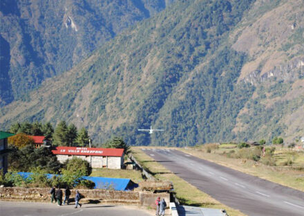

FAQs
-
What is the Gokyo Chola Pass Trek?
The Gokyo Chola Pass Trek is a challenging and scenic trek in the Everest region that combines the Gokyo Lakes, Cho La Pass (5,420m), and Everest Base Camp (5,364m), offering stunning views of the Himalayas, including Everest, Lhotse, and Makalu.
-
How long does the trek take?
The trek typically takes 15–18 days, depending on the itinerary, acclimatization days, and weather conditions.
-
What is the difficulty level of this trek?
It is considered challenging due to high-altitude trekking, steep ascents/descents, and crossing the Cho La Pass, which can be icy and technical.
-
When is the best time to do this trek?
Spring (March–May): Stable weather, bloomiAutumn (September–November): Best visibility, comfortable temperatures, and dry trails. Autumn (September–November): Best visibility, comfortable temperatures, and dry trails.ng rhododendrons, and clear skies.
-
Is there internet or mobile network availability?
WiFi is available in major villages (Lukla, Namche, Gokyo, Lobuche), but it can be slow and expensive.
-
Do I need travel insurance?
Yes, comprehensive travel insurance covering high-altitude evacuation (above 5,500m) and medical emergencies is mandatory.
