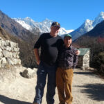
Trip overview
Overview: Manaslu Circuit 18-days trek
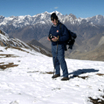
The Manaslu Circuit Trek revolves around the majestic Manaslu Massif (8,163 m), the eighth-highest mountain in the world. This less-crowded trekking route offers an alternative experience to the more popular trails in Nepal. The journey passes through traditional Hindu and Buddhist villages, providing a cultural immersion alongside breathtaking landscapes. Trekkers on the Manaslu Circuit are treated to panoramic views of snow‑capped giants, including Mt. Manaslu and Ganesh Himal. In Additionally, the trail unveils vast glaciers, lush forests, and picturesque countryside—all of which contribute to an unforgettable trekking experience. Moreover, the region’s diverse landscapes and rich biodiversity further deepen the adventure, imbuing it with both natural beauty and ecological intrigue.
Importantly, the Manaslu Circuit trek traverses a restricted area, requiring special permits and compliance with local regulation
Independent trekking is not permitted. To explore this extraordinary region, trekkers must obtain special permits and be accompanied by a licensed guide. Indeed, the permit process mandates at least two trekkers traveling with a registered local guide.
Manaslu Circuit Trek: Starting and Ending Points
The Manaslu Circuit Trek is one of Nepal’s most spectacular and culturally rich trekking routes, circling the majestic Mount Manaslu (8,163 meters), the eighth-highest mountain in the world. Notably, the trek—renowned for its unspoiled beauty, remote mountain villages, and Tibetan-influenced culture—commences in the lush lowlands and subsequently ascends into alpine terrain before ultimately culminating in a dramatic high-pass crossing.
Starting Point: Machha Khola (Approx. 870 meters)
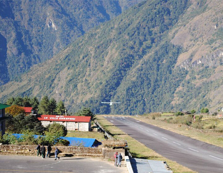
The trek typically starts at Machha Khola, a small riverside village in the Gorkha District of central Nepal. To reach Machha Khola, trekkers usually drive from Kathmandu to Soti Khola or Arughat, which takes about 7 to 9 hours depending on road conditions. In recent years, road development has extended vehicle access up to Machha Khola, eliminating the need for the initial day of walking from Soti Khola for many trekkers.
Machha Khola lies along the Budi Gandaki River, surrounded by terraced fields, tropical forests, and scattered villages. The trail from here begins gently, moving through narrow gorges and crossing numerous suspension bridges as it winds its way north.As trekkers ascend, they pass through several ethnic Gurung and Magar settlements, gradually encountering a growing Tibetan influence reflected in the region’s architecture and cultural practices.
From this point, the trail becomes increasingly rugged and remote, with the landscape changing from subtropical forest to high alpine meadows and glaciers as altitude increases.
History and Accessibility
Until 1991, the Manaslu Circuit Trek remained closed to foreigners. However, this changed after a Japanese expedition successfully summited Manaslu Peak (8,157 m), earning the mountain the nickname “Japanese Mountain.” As a result, the achievement drew international attention to the region. Since then, the trek has steadily gained popularity among adventurers seeking a remote and culturally rich Himalayan experience.. Many are drawn by its remote trails and culturally rich experiences. Furthermore, the route offers a rare combination of untouched natural beauty and traditional Tibetan-influenced villages. Altogether, the Manaslu Circuit presents a unique blend of adventure and cultural immersion..
Typically, the trek begins from Gorkha, Trishuli Bazaar, or Dhunche, with buses available from Kathmandu for easy access. Additionally, Dhading serves as an alternative starting point, providing trekkers with more route options to explore this breathtaking region. Permit fees are $90 per person per week from October to November and $75 per person per week for the rest of the year.
Trail Challenges and Tibetan Influence
The rugged trail is steep, narrow, and carved into cliffs high above the river. While Larkya La Pass is not technically difficult, the trek is demanding due to its sustained elevation gain, extended daily distances, and unpredictable mountain weather. Consequently, proper acclimatization, robust fitness, and thorough preparation are essential for a safe and enjoyable passage. remoteness. There are no rescue facilities or easy exit points, making preparation crucial. The region is deeply influenced by Tibetan culture, with locals in Nupri being direct descendants of Tibetan migrants. Their language, customs, and trade connections with Tibet remain strong. Furthermore, trekkers are rewarded with sensational mountain views and the dramatic Larkya Pass, thus rendering this journey both culturally and geographically unforgettable.
Lifestyle:
The Manaslu trekking area people are , primarily of Tibetan origin, lead a traditional mountain lifestyle. Most villagers rely on subsistence farming, growing barley, potatoes, and vegetables for daily survival. Moreover, some also engage in yak herding, which remains a vital part of their livelihood. Furthermore, trade with neighboring Tibet still thrives, bolstering their economy and cultural exchange. Communities exchange goods like salt, wool, and other essentials across the border.
While teahouse culture is gradually expanding along the trekking route, remote villages still offer homestays. These provide a deeper, more authentic Himalayan experience. Trekkers can fully immerse themselves in the local lifestyle by sharing daily routines, meals, and stories with their welcoming hosts.
Culture:
The region is home to Tibetan Buddhist culture, with numerous ancient monasteries, mani walls, and prayer flags along the trail. Major ethnic groups include the Gurung, Nubri, and Tsum people, who follow Tibetan customs. The influence of Tibetan Buddhism is seen in prayer wheels, chortens (stupas), and monasteries. Famous festivals include Lhosar (Tibetan New Year), Dhachyang (a horse racing festival), and Mani Rimdu.
Vegetation & Wildlife:
Lowlands (700 m-2,000 m): lush subtropical forests with rhododendron, oak, and pine. Mid-altitude (2,000 m-3,500 m): dense forests of fir, hemlock, and juniper. High altitude (above 3,500 m): Alpine meadows and barren landscapes. Wildlife includes the snow leopard, Himalayan tahr, musk deer, red panda, and various species of pheasants.
Highlight Points:
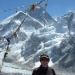
Mt. Manaslu (8,163 m) Views: The eighth highest mountain in the world, Mt. Manaslu, dominates the landscape throughout the trek, offering awe-inspiring views. Its towering presence adds to the grandeur of the journey, making it a highlight for trekkers.
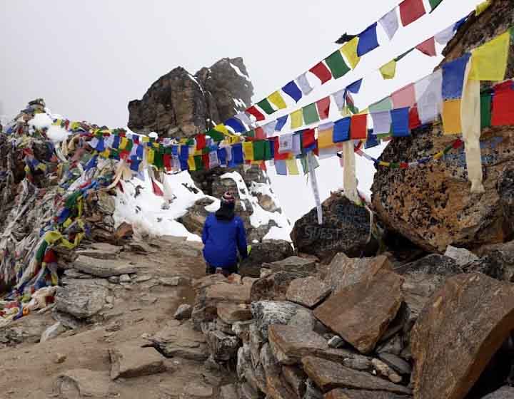
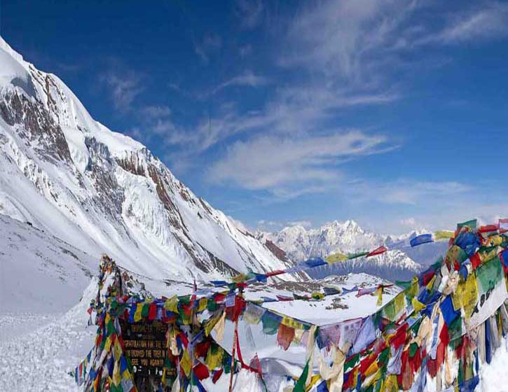
Larkya La Pass (5,160 m): The highest point of the Manaslu hiking is one of the most thrilling passes in Nepal, offering panoramic views of the surrounding peaks, including Himlung, Kang Guru, and Annapurna II. The challenging ascent and breathtaking scenery make it a memorable part of the adventure.
Rich Cultural Experience: Explore the Tibetan-influenced culture of the Gurung and Tamang people in villages like Samagaon and Samdo. Visit ancient monasteries, mani walls, and prayer flags along the trail, gaining insight into the spiritual traditions of the region. Notably, the circuit is less crowded than other popular treks like Everest or Annapurna, thereby offering solitude and untouched landscapes.
Diverse Landscapes: Experience a dramatic change in scenery, from subtropical forests and terraced fields to alpine meadows and glacial valleys. The trek provides an ever-changing natural backdrop that keeps every day exciting and unique.
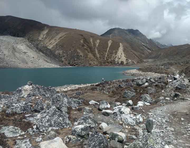
Birendra Tal (Lake): A stunning glacial lake near Samagaon that reflects the peaks of the Manaslu range. The serene waters and surrounding scenery make it a perfect stop for trekkers to rest and take in the beauty of the Himalayas. Tsum Valley (Optional Extension)
Tsum Valley: A Hidden Gem
Nestled deep within the Himalayas, the Tsum Valley reveals an exceptionally remote and culturally vibrant retreat. Rich with Tibetan Buddhist monasteries, this off‑the‑beaten‑path haven invites travelers to explore age‑old rituals and unique local traditions. Far from the well‑trodden routes, it offers both spiritual discovery and breathtaking mountain scenery.
Perhaps there was a misunderstanding, or the text you intended to provide was different. Additionally, its seclusion has safeguarded ancient customs and a traditional way of life, thus enabling visitors to observe centuries-old practices that have endured largely unaltered. Consequently, Tsum Valley emerges as the quintessential destination for those in search of both thrilling adventure and profound cultural immersion. Adding to this allure, every step along its winding trails offers an intimate encounter with living heritage, and to complete the picture, the warm hospitality of local communities further enriches the experience.
This secluded valley offers trekkers a rare opportunity to experience the untouched beauty and spiritual depth of the region. Moreover, its isolation has helped preserve ancient customs and a traditional way of life, allowing visitors to witness centuries-old practices that remain largely unchanged. Consequently, Tsum Valley stands out as an ideal destination for those seeking both adventure and meaningful cultural immersion.
Diverse Wildlife in Manaslu Conservation Area
Remarkably, the Manaslu Conservation Area boasts an incredibly diverse array of wildlife. In particular, it shelters elusive species such as snow leopards, Himalayan tahr, and red pandas, delighting nature enthusiasts at every turn. Additionally, its lush forests, alpine meadows, and glacial rivers create a breathtaking backdrop that continually heightens the trekking experience. Consequently, the region’s rich biodiversity and pristine landscapes not only enhance its appeal but also provide trekkers with a rare opportunity to immerse themselves in an unspoiled natural haven.
Adding to the richness of the experience, the authentic villages scattered along the trail invite exploration and discovery. For example, picturesque settlements such as Jagat, Namrung, and Lho not only offer stunning mountain vistas but also grant unique insights into local culture and daily life. Beyond this, trekkers can partake in the warm hospitality of villagers, observing traditional customs and lifestyles firsthand. Thus, each encounter further enriches the cultural tapestry of the journey.
Comfortable teahouses along the trail provide cozy accommodation and authentic Nepali meals, adding to the trekking experience. This trek combines adventure, culture, and natural beauty, making it a favorite for trekkers looking for a unique Himalayan experience.
Popular Trekking Routes in Nepal:
Everest Region Treks
Everest Base Camp Trek (EBC) (12-14 days)—The most iconic trek, offering breathtaking views of Mt. Everest.
Gokyo Valley with Renjo La Pass Trekking (13-16 days)-A challenging trek crossing Renjo La Pass.
Everest Three Passes Trek (18-21 days)—A challenging trek crossing Renjo La, Cho La, and Kongma La passes.
Gokyo valley with fifth lake trekking (12-15 days) The most iconic trek, offering breathtaking views of Mt. Everest.
Gokyo Lakes Trek (12-14 days)—Stunning trek featuring glacial lakes and the Gokyo Ri viewpoint.
Everest View Trek (5-7 days) – A shorter trek with great views, ideal for beginners.
Annapurna Region
Annapurna Base Camp (ABC) Trek (7-12 days) – A moderate trek leading to the base of Annapurna.
Ghorepani Poon Hill Trek (4-7 days)—A short and scenic trek with sunrise views from Poon Hill.
Mardi Himal Trek (5-7 days)—A less crowded trek with panoramic views. Langtang Region Treks
Annapurna Circuit Trek (14-20 days)—A classic trek crossing Thorong La Pass (5,416 m).
Langtang Valley Trek (7-10 days)—A beautiful trek through Tamang villages and alpine landscapes.
Gosaikunda Trek (5-8 days)—A religious trek to sacred alpine lakes.
Tamang Heritage Trail (6-8 days)—A cultural trek through traditional Tamang villages.
Manaslu & Restricted Area Treks
Manaslu Circuit Trek (14-18 days)—A remote and less crowded trek around Mt. Manaslu.
Tsum Valley Trek (14-20 days)—A cultural trek to the hidden valley of Tsum.
Upper Mustang Trek (10-14 days) – A unique desert-like landscape with Tibetan culture.
Upper Dolpo Trek (20-30 days)—A challenging trek to an isolated region with stunning scenery.
Short Treks Near Kathmandu & Pokhara
Australian Camp Trek (2-3 days)—A short and easy trek near Pokhara with beautiful views.
Shivapuri Nagarkot Trek (2-4 days)—A scenic trek near Kathmandu.
Chisapani-Nagarkot Trek (2-3 days)—A short and easy trek with Himalayan views.
Conclusion: Manaslu Circuit Trek
The Manaslu Circuit Trek is an extraordinary adventure that offers trekkers a perfect blend of natural beauty, cultural diversity, and remote wilderness. As one of Nepal’s most rewarding yet less crowded trekking routes, it takes you through lush forests, traditional villages, and breathtaking high-altitude landscapes, culminating in the challenging Larkya La Pass (5,106 m).
Manaslu Circuit Hiking 18-Day Trek. With the increasing popularity of the trek, proper preparation and adherence to permit regulations are essential for a safe and enjoyable journey.
Short Itinerary
Day 1: Arrival in Kathmandu (preparation day, gear check).
Day 2: Drive to Soti Khola (700 m).
Day 3: Trek to Machha Khola (870 m).
Day 4: Trek to Jagat (1,340 m).
Day 5: Trek to Deng (1,860 m).
Day 6: Trek to Namrung (2,630 m).
Day 7: Trek to Samagaun (3,530 m).
Day 8: Acclimatization day at Samagaun (optional hike to Pungyen Gompa or Manaslu Base Camp).
Day 9: Trek to Samdo (3,860 m).
Day 10: Acclimatization day at Samdo (short hike to the Tibetan border).
Day 11: Trek to Dharmasala (4,460 m).
Day 12: Cross Larkya La Pass (5,160 m) and descend to Bimthang (3,590 m).
Day 13: Trek to Tilije (2,300 m).
Day 14: Trek to Dharapani (1,860 m).
Day 15: Drive to Besisahar and onward to Kathmandu.
Day 16: Free day in Kathmandu (sightseeing, shopping, rest).
Day 17: Buffer day (in case of delays).
Day 18: Departure.
Itinerary
Early morning after berekfast take a car from the hotel and drive to to the bus stationation and then start form kathmandu to Aarughat bazar it take about 7-8 hrs by local bus.
Aarughat to Sati Khola:730 meters (2,395 ft)The trek starts to go ahead to Sati Khola via Sante Bazaar and Budhi Gandaki valley and reaches to Koirpani, a small village of Magar and Gurung. The trail descends to Ahati Khola. There is a small waterfall just above the trail, a larger waterfall with a 60-meter drop is visible by climbing upstream. This valley is famous for honey, which is harvested in a manner as described in the book “Honey Hunters of Nepal”.
Sti Khola to Labu Besi: After crossing the bridge, the trek climbs up onto a ridge above the huge rapids of Budhi Gandaki and reaches to Khorsaani. Then it, the trail, gets a bit precarious as it passes over a big rock and crosses a stream. The rocky trail then goes up and down through a large stand of nettles, passes tropical waterfalls and again backs down to the bank of Budhi Gandaki. The trek goes up again on a steep rocky trail and down then up around to the Gurung village of Labu Besi and rests overnight.
Labu Besi to Doban: The trek forwards to Machha Khola after crossing several streams on the way and reaches to the place where a cable ropeway is hanging over Budhi Gandaki, it should be crossed in a small cable car called “Girling”. The trail again forwards to Doban Khola via Khorlavesi, Tatopani, etc.
Doban to Jagat: The route climbs on a Rugged Rocky trail to Duman. Then passes the villages of Yaru Khola, Thado Bharyang and crosses Budhi Gandaki again and climbs over a ridge; trek along the river for a while and reaches to the compact village of Jagat at 1410 meters.
Jagat to Serson: The trek climbs over a rocky ridge up to salleri. Shringi Himal offers good views from this Village. The trail descends to Setibas (Tara) a Gurung village influenced by Tibetan culture. Continuing upstream, the trail follows the best and new route to Manaslu via Ngyuak (Nyak), climbs up to Philim (Dodang) at 1550 meters. The trail then leads to Ganesh Himal is called Tsum. It is still off-limits to foreigners. This village of Tsum is inhabited by Tibetans and is towards Tibet across to passes ahead of the Shar Khola ( East River ) Valley. Later on, the trail reaches to serson.
Serson to Deng: After serson, The trail enters a steep uninhabited gorge and descends through grassy slopes dotted with tall pine trees then, the trail hangs on a cliff after crossing the Budi Gandaki. The tiny village Deng comes after crossing a bamboo forest and Deng Khola (river)
Deng to Ghap: today the trail re-crosses Budi Gandaki and climbs up then passes a waterfall after crossing a stream it continues to climb ahead before dropping to Shring Khola crosses it and climbs steeply to reach to Ghap( task) Many of the carvings of Buddha in various meditative poses and others are of the Tibetan saint Milarepa who is said to have travel and meditated in this valley.
Ghap to Namrung: The trail then crosses a 26 meters long bridge over Budi Gandaki at 2100Meters and passes more many stones to enter in to the woods then, the trail climbs two long main walls and a waterfall will be on the way to village at Budi Gandaki Valley which is a trading route to Tibet. The trek climbs over a big rock and continues up through deep fir and Rhododendron. the forest entering Namrung (Nsamdru) through a stone archway at 2600 meters, there are excellent camps in the forest, another part of Namrung remains across the bridge.
Namrung to Shya: After Numrung the trail follows the Nupri region, a region, a region of Tibetan immigration. On the way village Li at 2900meters, the trail passes village Barcham (Bartsam) and the forest of fire and rhododendron. The trail leaves the village and crosses Hinan Khola and reaches to Sho Sho, where children demand Shim a Tibetan word for Sweets or candy. After leaving Budi Gandaki valley, the spectaculars views of Mt. Manaslu, Manaslu north (7154m) and Naike Peak come into sight. The Trail then follows to Lho ( Lo) at 3100meters pass Shrimp, a small settlement. Lho is a big village with gompa (Monastery) a stone Archway at the entrance of a Tibetan style Chorten and a huge Mani wall. The Trail drops down to cross Damonan Khola, Starts to ascend again and finally emerges onto a platue at shya (3520m.) with wide views of Himal chuli, Ngadi chuli, and Manaslu.
Shya to Gompa: The trail crosses a ridge and descends on to a tock- strewn Moraine then emerges on to a ridge overlooking pastures and fields of Samagaon (Ro) the samaGompa is nestled against a wooded moraine at the far end of the valley. Spare a day to climb the ridge to the south of Samagaon to the Pung- Gyen Gompa hidden behind the ridge in front of Manaslu. The Japanese call this Honsanso Gompa. An avalanche destroyed it in the winter of 1953, killing 18 inhabitants.
Sama Gompa to Samdo: The trail descends to Budhi Gandaki and leads to Manaslu Base “Camp. The Larkya La trail passes several Manmu walls and reaches to Kermo Kharka after crossing the Juniper, Birch forest. The trail then climbs steeply to find Samdo nestled behind a bridge at 3860m. Somewhere in the village, a police Cheak post lurks’ a major trade route to Tibet heads ahead east through the village over Lajyang La at 5098m. A day’s walk from here.
Samdo to Larkya Resthouse: The trek descends to the river and crosses it then proceeds on to climb to Larkya La. Again climb gently through Juniper and Tundra opposite to Larkya La Glacier. The trail gets steeper and climbs the side of the ridge about 4000m. Where there is a viewpoint at the edge of a huge gorge. The trail climbs in and out of the and reaches the only shelter on the route to the pass, a rest house at 4480.
Larkya Resthouse to Bimtang: Starting up the ridge in front of the rest house the trail reaches at the top of the moraine at 7400m. And climbs steeply to the pass at 5100m. It takes about 3/4hrs. To reach the pass so, it is best to start earlier. The tremendous views of Himlung Himal (7126m.) Cheo Himal (6820m.) Gyaji Kung, Kang Guru (6981m.) and Annapurna II (7937m.) can be seen on the west from here. Then the trail descends to Bimtang (3720m.), which means “Plain of Sand” in the Tibetan language. This a huge valley surrounded by high peaks.
Bimatang to Gho: The trek descends to Dudh Khola and reaches to Gho at 2560m. crossing Pine and Rhododendron forest via Hompuk, Karchep village. At foot of the valley, part of Lamjung peak above the Marsyangdi valley comes into sight.
Gho to Dharapani: The trail continues through the fields with rhododendron Oak forests to Dharapani via Tilje (Tiljet), Thonje (Thangjet villages. In Thonje, the Sirdar of Liaison Officer will contact the police to show off the collected garbage to obtain a clearance certificate. Afterward, the trek follows the trail to Dharapani (1920m.) for rest overnight.
Dharapani to Beshisahar by jeep about 6 hrs
Besi Shahar to Kathmandu: From beshi Shahar vehicles are available to Kathmandu.
Included
- All airport and hotel transfers
- 2 Night hotel in Kathmandu with B/B plan
- Conservation permit
- Kathmandu to Aarughat Bus ticket and Bashishahar to Kathmandu
- Accommodation, food, & Tea/coffee during treks
- Guide:- including salary, insurance, equipment, bus transportation, flight fare, food, and lodging
- Porter:- including salary, insurance, equipment, bus transportation, food, and lodging
Not Included
- Food in Kathmandu ( Lunch & Dinner)
- Nepal Visa fee
- International airfare from your country to Kathmandu and from Kathmandu
- Extra night accommodation in Kathmandu
- Travel and rescue insurance if guest get mountain sickness and need to rescue helicopters.
- Personal expenses example (phone calls, laundry service, bar bills, battery recharge, extra porters, bottle or boiled water, shower etc)
- Tips for guide and porters
Join Us Upcoming Trips
Book this trip with us. Here are the upcoming dates. Feel free to share this trip with your friends and family. For custom trips or general inquiries contact us.
| Departure Date | Trip Duration | Price | Status | |
|---|---|---|---|---|
| 02 October, 0025 | 18 days | $2210 | Fixed departure | |
| 14 October, 2025 | 18 days | $2210 | Fixed departure | |
| 26 October, 2025 | 18 days | $2210 | Fixed departure | |
| 05 November, 2025 | 18 days | $2210 | Fixed departure | |
| 15 November, 2025 | 18 days | $2210 | Fixed departure | |
| 30 November, 2025 | 18 days | $2210 | Fixed departure | |
| 10 December, 2025 | 18 days | $2210 | Fixed departure |
Useful Info
Duration: 18 days
Difficulty: Moderate to Strenuous
Maximum Altitude: Larkya La Pass (5,160 m / 16,930 ft)
Starting Point: Soti Khola (700 m / 2,297 ft); Ending Point: Dharapani or Besisahar
Permit Requirements:
1. Manaslu Restricted Area Permit (RAP) 2. Manaslu Conservation Area Permit (MCAP) 3. Annapurna Conservation Area Permit (ACAP)
Essential Gear: Clothing: Layered trekking outfits, down jacket, rain jacket, gloves, hat, and thermal base layers. Footwear: waterproof trekking boots, extra socks. Equipment: trekking poles, sleeping bag (-15°C rating), headlamp, water purifier, and daypack. Accessories: sunglasses, sunscreen, lip balm, a first aid kit, snacks, and cash (ATMs are unavailable on the trail).
FAQs
-
What is the Manaslu Circuit Trek?
The Manaslu Circuit Trek is a remote and adventurous trekking route in Nepal that circles Mt. Manaslu (8,163m), the world’s eighth-highest peak. This 18-day trek offers diverse landscapes, Tibetan-influenced culture, and a stunning high-altitude crossing at Larke Pass (5,106m).
-
How difficult is the trek?
The trek is moderate to challenging due to long walking hours, high altitude, and steep ascents/descents. It requires good fitness and some trekking experience.
-
What is the best time to do the trek?
Spring (March–May): Clear skies, blooming rhododendrons, and mild temperatures. Autumn (September–November): Best visibility, pleasant weather, and stable conditions. Winter (December–February) is very cold and snowfall can block the pass, while the monsoon (June–August) brings heavy rain and landslides.
-
Do I need a permit for the trek?
Yes, the trek falls under a restricted area, so you need: a, Manaslu Restricted Area Permit (MRAP), b, Manaslu Conservation Area Permit (MCAP) c, Annapurna Conservation Area Permit (ACAP) and minimum of two trekkers is required, and you must trek with a government-licensed guide.
-
What is the highest point on the trek?
The highest point is Larke Pass (5,106m), offering stunning views of Mt. Manaslu, Himlung, Cheo Himal, and Annapurna II.
-
What is the total trekking distance?
The total trekking distance is approximately 177 km (110 miles), covering 10–20 km per day.
-
What type of accommodation is available?
Tea houses/lodges: Available along the route, offering basic rooms with twin beds. Food: Dal Bhat (rice and lentils), noodles, soups, momo (dumplings), and some Western options.
-
What should I pack for the trek?
Clothing: Warm layers, waterproof jacket, thermal base layers, gloves, and a hat. Footwear: Sturdy trekking boots with good grip. Gear: Sleeping bag (-10°C), trekking poles, sunglasses, sunscreen, and a refillable water bottle. First-aid kit: Diamox (for altitude), painkillers, bandages, and personal medications.
-
Is there electricity and Wi-Fi on the trek?
Electricity: Available in lower regions, but limited at higher altitudes. Charging may cost $2–$5 per device. Wi-Fi: Available in some villages but is slow and expensive.
-
Is travel insurance necessary?
Yes, travel insurance is mandatory and must cover high-altitude trekking (above 5,000m), emergency evacuation, and medical expenses.
-
Why choose the Manaslu Circuit over Everest or Annapurna?
a, less crowded than Everest and Annapurna. b, More remote and culturally rich with Tibetan influence. c, Spectacular mountain scenery and diverse landscapes.